When the World is the Canvas
 The saying "art mimics life" generally holds true, but what you will see in this case is exactly the opposite: This is life that looks like art.
All the images here are not gorgeous abstract paintings or patterns on a tapestry but satellite images, part of the NASA collection.
The collection so far includes more than one hundred thousand images and while it is pretty well organized (by country, type of satellite, US State and others) it is almost impossible to go through it in just a couple of hours (or days!).
Some images are thermal, some are animations based on the information received and some look like pictures from a lomo camera. I picked the ones that struck me more representative of some kind of art. I think that all of them nicely framed and hang from a wall, can pass for art.
Make sure you click to enlarge the pictures to be able to see them in detail and let's start with the clouds...
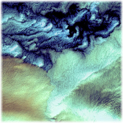
According to NASA, what looks like a painting with strokes of Monet and Renoir, is in fact the image of cloud formations that were seen over the western Aleutian Islands. Their color variations are probably due to differences in temperature and in the size of water droplets that make up the clouds.
What could perfectly be an acrylic painting is in fact an image of the Kachchh region in western India that suffered the most deadly earthquake in India’s history. This shaded topography view of landforms northeast of the city of Bhuj depicts geologic structures that are of interest in the study the tectonic processes that may have led to that earthquake. However, preliminary field studies indicate that these structures are composed of Mesozoic rocks that are overlain by younger rocks showing little deformation. Thus these structures may be old, not actively growing, and not directly related to the recent earthquake.
In this image, colors range from green at the lowest elevations, through yellow and red, to purple at the highest elevations.
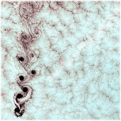
Each of these swirling clouds is the result of a meteorological phenomenon known as a von Karman vortex. These vortices appeared over Alexander Selkirk Island in the southern Pacific Ocean. Rising precipitously from the surrounding waters, the island’s highest point is nearly a mile (1.6 km) above sea level. As wind-driven clouds encounter this obstacle, they flow around it to form large, spinning eddies. The remind me of sheep skin or of something worked out in cotton.
In this case the image has something of a flower, and probably because of its shape it reminds me of a tropical carnivorous plant. But this is the thermal infrared false color image of Mauna Loa volcano, Hawaii, that shows lava flows in different colors from each other, due to their relative ages.
These images of the San Francisco Bay region are from 2000 and each one covers an area 60 kilometers (37 miles) wide and 75 kilometers (47 miles) long. The almost seem like a picture taken with a lomo camera but according to NASA, this is how it goes:
- In the upper left, the color infrared composite uses bands in the visible and reflected infrared. Vegetation is red, urban areas are gray; sediment in the bays shows up as lighter shades of blue. Thanks to the 15 meter (50-foot) spatial resolution, shadows of the towers along the Bay Bridge can be seen.
-In the upper right, a composite of bands in the short wave infrared displays differences in soils and rocks in the mountainous areas.
- In the lower left, the composite of multispectral thermal bands shows differences in urban materials in varying colors.
- The lower right is a color coded temperature image of water temperature, derived from the thermal bands. Warm waters are in white and yellow, colder waters are blue. Suisun Bay in the upper right is fed directly from the cold Sacramento River. As the water flows through San Pablo and San Francisco Bays on the way to the Pacific, the waters warm up.
This case is very interesting because you can call this a history map or "landscape archaeology". This image produced from data acquired by the Airborne Synthetic Aperture Radar basically reveals the history of sea islands in the Altamaha River delta on the coast of Georgia. The outlines of long-lost plantation rice fields, canals, dikes and other inlets are clearly defined. Salt marshes are shown in red, while dense cypress and live oak tree canopies are seen in yellow-greens.
Agricultural development of the Altamaha delta began soon after the founding of the Georgia Colony in 1733. About 25 plantations were located on the low-lying islands and shores by the 19th century, taking advantage of the rich alluvial flow and annual inundation of water required by some crops. The first major crop was indigo; when demand for that faded, rice and cotton took its place.
A major storm in 1824 destroyed much of the town of Darien (upper right) and put many of the islands under 20 feet of water. The Civil War ended the plantation system, and many of the island plantations disappeared under heavy brush and new growth pine forests.
Some were used as tree farms for paper and pulp industries, while the Butler Island (center left) plantation became a wildlife conservation site growing wild sea rice for migrating ducks and other water fowl. Margaret Mitchell is reputed to have used the former owner of the Butler Plantation as a basis for the Rhett Butler character in her novel "Gone With The Wind," taking the first name from Rhett's Island (lower right).
The Lena River, some 2,800 miles (4,400 km) long, is one of the largest rivers in the world. This is a false-color composite image made using shortwave infrared, infrared, and red wavelengths. I can't pinpoint whose artwork it reminds me of but... it is no doubt another painting.
I love the intrincate detail in this image. It seems like a drawing made with ink, but it is the Mayn River -seen here with what is thought to be a portion of the Anadyr River- a river that flows through the far northeastern corner of Siberia.
All these images are available online at the "Visible Earth Collection" from NASA, where if you have time enough you can browse an impressive collection of 102521 images!


No comments:
Post a Comment